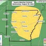
A slight chance of severe weather is expected Wednesday afternoon and evening across north central Arkansas, according to the National Weather Service (NWS). Forecasters indicate that the primary threats include high winds and an isolated potential for hail.
The latest NWS briefing places the area under a level 2 out of 5 risk for storms. Simulated radar suggests storm activity could begin developing along the Missouri-Arkansas border around 3 p.m., with the threat continuing through approximately 9 p.m.
While tornado risk is not currently forecast, residents are urged to remain alert for damaging winds and heavy thunderstorms, which could cause localized flash flooding. However, both the damaging wind and hail threats are categorized as low, according to the briefing. Rainfall in Mountain Home is predicted to total about a quarter inch.
Local officials encourage residents to monitor updates from trusted sources throughout the day.